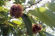
North Coast Local Land Services is working with macadamia growers to help develop Erosion Management Plans designed to reduce land degradation and improve farm viability.
Land Services Officer for North Coast Local Land Services, Kel Langfield, said they were working with Geological Exploration Services (GES) and a number of macadamia growers who were interested in improving their overall orchard productivity by reducing erosion.”
“Light Detection and Ranging (LIDAR) technology is providing crucial data and information for the development of the Plans,” Mr Langfield said.
LIDAR is a remote sensing technique that uses laser to map a three-dimensional view of a property.
Every point that is mapped can be given an attribute, or feature, such as a building, ground, vegetation or water.
The map can then be used to identify areas of differential management in orchards using models for digital elevation, vegetation and erosion.
Each Erosion Management Action Plans consists of a detailed set of maps specific to each individual orchard.
In addition to the mapping, an Action Plan is developed for each orchard, which identifies the priority issues including drainage, canopy and orchard floor management and what can be done to address these issues. The plan is developed during an individual property visit involving an inspection of the orchard and discussions with each individual grower.