Ethiopia's National Horticulture Strategy sets out targets to expand the sector's economic role, raising its contribution to GDP from 4.5 per cent to 12 per cent, increasing foreign earnings from US$650 million to US$3.3 billion, creating employment for 2 million people, doubling per capita fruit and vegetable availability from 50.2 kilograms to 102 kilograms per year, and sequestering 131 million tons of carbon dioxide over the next decade.
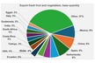
The strategy comes as Ethiopia positions horticulture alongside manufacturing as a growth sector. Fruits such as table grapes, avocados, strawberries, mangoes, and bananas, vegetables including tomatoes, onions, and peppers, herbs, and floriculture crops are produced across 18 agroecological zones. These range from highland areas suited to temperate crops to lowland regions supporting tropical production. The sector supports rural employment and supplies agro-processing activities such as juicing, canning, and drying.
Despite this breadth, growth remains constrained by fragmented supply chains, limited cold storage, water and power shortages, and transport bottlenecks linking production areas to export hubs. Recent investments, including the Cool Port Addis facilities at Mojo Dry Port and the Ethiopia–Djibouti railway, improve perishables handling and transit times, but effective planning remains essential to align production with logistics capacity.
A reference point exists in the Manufacturing Industry Resource Atlas, developed under the Ministry of Industry in cooperation with the World Bank. Launched in draft form in July 2025, the platform compiles GIS-compatible datasets covering water resources, energy networks, transport corridors, ICT coverage, labour and skills, industrial parks, agriculture, and manufacturing firms. The atlas enables spatial analysis to identify areas where infrastructure and resources converge, supporting investment decisions and policy planning.
A comparable Horticultural Resource Atlas under the Ministry of Agriculture would apply a similar framework to crop production. Such a tool could map soils, climate zones, surface and groundwater availability, labour pools, power supply, telecom coverage, roads, rail links, and proximity to cold chain infrastructure, dry ports, and airports. Crop-specific data, such as production clusters in the Rift Valley, Sidama, or along the Awash basin, could be layered with logistics and energy access.
The national strategy outlines eight horticultural development corridors, 200 clusters, and 10 horti-parks over the next decade. Spatial mapping could support site selection for these projects, help coordinate irrigation and transport investments, and link horti-parks with universities and TVET institutions for skills development. It could also support climate planning by integrating variability and drought exposure into location decisions.
As with manufacturing, geospatial planning would not replace agronomic or market analysis but would provide a structured overview of constraints and opportunities. For high-tech greenhouse operators and exporters, such an approach could improve alignment between production systems, infrastructure, and market access as Ethiopia works to scale horticulture within its broader economic framework.
Source: Floriculture