The FAO estimates that by 2050 the demand for food, fibre and fuel will double, leading the scientific community to face the challenge of increasing agricultural productivity. Among the major factors linked to production losses, most important are pests and agricultural diseases, which cause significant losses all over the world. One of the most widespread leaf diseases on the planet is yellow Sigatoka (Mycosphaerella musicola) that is a major factor limiting cultivation of the banana and it is present in all banana-producing regions of the world.
In the context of precision agriculture, the interest for agricultural remote sensing tools is increasing. In the field of remote sensing, Unmanned Aerial Vehicles (UAVs) and machine learning (ML) tools have revolutionized remote data processing. UAV technology provides high spatial resolution images, increasing the accuracy of input data for computational processes, while ML tools carry out the manipulation, interpretation and generation of the results. These techniques are the basis of the four stages of decision-making during the monitoring cycle of a unique phenotypic characteristic that are identification, classification, quantification and prediction.
Scientists at Federal University of Ceara (Fortaleza, Brazil) have used high spatial resolution aerial images to monitor the severity of an attack of yellow Sigatoka in a banana crop.
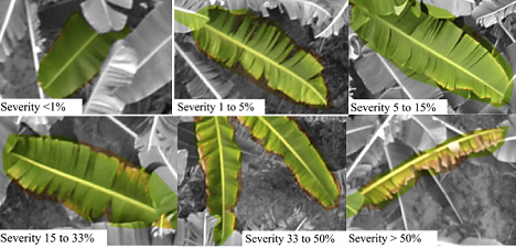 Symptoms of an attack of yellow sigatoka in banana leaves. Aerial images obtained with the Inspire 1 UAV.
"The large volume of data from the images obtained with the UAV was of great importance for the high levels of accuracy of the algorithms obtained in identifying and classifying leaf spot in the banana. High spatial resolution RGB images obtained using the UAV proved to be powerful as input data for training supervised classification algorithms - the scientists explain - The level of detail of the images was a crucial factor in severity disease assessment. The severity of a yellow Sigatoka attack can be calculated by aerial images obtained with UAVs and digital image processing, and can be seen as an alternative method for estimating and quantifying the damage found in the field. Furthermore, the system provides humidity and temperature conditions data that can help to better assess and manage the disease."
Source: Vinícius Bitencourt Campos Calou, Adunias dos Santos Teixeira, Luis Clenio Jario Moreira, Cristiano Souza Lima, Joaquim Branco de Oliveira, Marcio Regys Rabelo de Oliveira, 'The use of UAVs in monitoring yellow Sigatoka in banana', 2020, Biosystems Engineering, Vol. 193, pages 115-125.