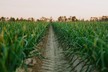
Northern Maine potato growers are entering a brave new world. This past summer Wayne Kilcollins, Northern Maine Community College instructor of wind power technology, found himself above the northern Maine potato fields using cutting edge drone technology to record variations in potato crop yields and quality.
What’s going on is the combining of aerial, unmanned drone technology and computer-based global information systems — or GIS — to give farmers real time information that can be used to treat current crops and plan for future plantings.
The system is the brainchild of Raptor Maps, based in Cambridge, Massachusetts, and is the future of farming, according to founder and CEO Nikhil Vadhavkar.
“I had seen drone technology being used in agriculture but the farmers were not getting a ton of value from it,” the Massachusetts Institute of Technology graduate and engineer said. “They would get these maps with colors like ‘red means bad’ and ‘green means good’ on their fields, but no other information articulating what the data was saying.”
The company got its start in 2015 when it won the MIT Entrepreneurship Competition and $100,000.
“With Raptor Maps, we wanted a ‘grower first’ mentality,” Vadhavkar said. “We wanted to work directly with growers on what were the problems costing them money and how can we build a system around solving them.”
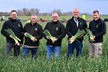
The MIT crew, which includes Vadhavkar’s fellow MIT alumnae, Eddie Obropta and Mike Klinker, ultimately developed a system which is now tracking potatoes, onions, tomatoes, beets, carrots and citrus in Maine, Idaho, Washington and California.
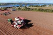
On the ground in Maine, Raptor Maps installs a computerized monitoring sensor system directly on the “boom” — the conveyor belt that transports freshly dug potatoes from the harvester to a truck — that tracks each tuber as it rushes by and records size, weight and quantity.
This information is then paired with data recorded by drones flying over the same fields.
Once correlated, a farmer has a detailed analysis of how the potato crop did over every inch of the fields and what may need to be done to improve certain areas.