California continues to experience a massive drought, which enables wildfires to expand more rapidly. Last week’s heat wave led to a further increase of burned acreages and resulted in Governor Jerry Brown issuing a state of emergency.
Firefighters continue to battle the many wildfires in the state. West of the state’s capital Sacramento, the Valley Fire in Lake County has burned more than 61,000 acres since it began on Saturday. To the East of Sacramento, the Butte Fire has burned more than 71,000 acres since it began last Wednesday. By far the biggest wildfire started with a lightning strike on July 31 and has since burned more than 138,000 acres in the national parks Sequoia and Kings Canyon.
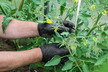
Lake County’s main agricultural crop is wine grapes, but it also grows a few thousand acres of walnuts as well as about two thousand acres of pears. The main agricultural crop for Amador and Calaveras counties, which are being hit by the Butte Fire, is wine grapes.
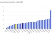
LA Times has visualized the severity of California’s drought by showing 194 drought maps from December 2011 until September 2015. Click this link to see the maps. As a result of the drought, most reservoirs are less than 50 percent full with some nearing 20 percent of capacity. The maps show the desperate need for cooler weather and rain.

Source: LA Times