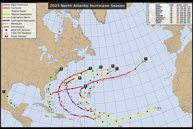
The hurricane season in the U.S. typically runs from June 1 until November 30. While the season certainly isn't over yet, it seems to be quieter compared to previous seasons. So far, ten tropical cyclones have been named and there have been two category five storms. Even though these storms have not threatened the U.S., their numbers and intensities do fit a relatively normal curve.
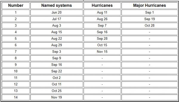
"Typically, there would be nine named storms by September 16," says Drew Lerner with World Weather, Inc. "We are running a little late as it took until October 1 to register nine named storms this year. With the recent evolution of Tropical Storm Jerry, relative to the October 11 norm we are about two storms fewer than the normal." The two major hurricanes seen this year are close to the norm as well." However, the norm is based on a 30-year average while in recent years, the number of active storms has increased. With the old norm being 10-12 storms in the summer season, the number has stretched to 14 in recent years. For that reason, the number seems to be much lower this year compared to the last few years.
The table below shows the 30-year average Atlantic hurricane season development.
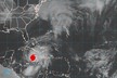
 © U.S. National Hurricane Center/NOAANormally, there would have been nine named storms by September 16. Credit: U.S. National Hurricane Center/NOAA.
Changes in wind speed and direction
The biggest reason for the lighter tropical cyclone season is probably wind shear aloft over the Atlantic Ocean. The greater wind shear tends to prevent storm development and keeps storms smaller and weaker biased. In addition, Sahara dust also plays a role. It blows off the African desert and gets into the air, inhibiting storm development.
What has also been helpful this year is that the storm track for tropical cyclones in the Atlantic Ocean has been favoring a path away from North America. The driving force for storm movement is usually the subtropical jet stream which is largely controlled by the "Bermuda High" pressure system. This system controls the wind direction and speed in the tropical Atlantic. In some years, the Bermuda High will move around pushing tropical storms in different directions, but this year's high-pressure system has been quite persistent in one general location, keeping the storms away from North America.
 © U.S. National Hurricane Center/NOAA
Credit: U.S. National Hurricane Center/NOAA.
Fruits and vegetables
Hurricanes have the potential to cause a lot of damage to fresh produce. In recent years, a number of tropical cyclones induced serious damage to crops and property, but the lack of land-falling storms this season has helped protect fruit and vegetable crop development and minimized losses in fruits and vegetables in many areas across the southern United States.
Despite the hurricane season being much lighter so far, it isn't over yet, leaving time for change. "I wouldn't be surprised to see at least one storm impact the southeastern U.S., but that storm may come from the Caribbean Sea or Gulf of America rather than from the Atlantic Ocean," Lerner concluded.
In the next few days, an article will be published on general weather conditions in the U.S. this year and the impact on fresh produce.
![]() For more information:
For more information:
Drew Lerner
World Weather, Inc.
Tel: (+1) 913-383-1161
[email protected]
www.worldweather.cc